THE INSECTICIDE-RESISTANT MOSQUITO
2.13
Managing insecticide resistance through maps
It is essential that insecticide resistance information from around the world is collated, shared and used in order to make informed, evidence-based decisions on vector control.
Mapping tools and maps are effective ways to collate and share this information. These maps can be used by researchers and malaria policy implementers as a source to help understand insecticide resistance trends and identify data gaps.
In 2012, the WHO Global Plan for Insecticide Resistance Management in Malaria Vectors (GPIRM) called upon malaria stakeholders to take action against insecticide resistance. Two approaches in the GPIRM’s multi-pillar strategy are particularly relevant to maps and mapping.
Firstly, it refers to “ensuring proper, timely entomological and resistance monitoring, and effective data management.” A second approach stresses the need for “filling gaps in insecticide resistance data and knowledge on mechanisms of insecticide resistance.” These highlighted the challenge that a centralised platform, from which insecticide resistance data could be accessed for planning and decision-making, was missing.
To help address this challenge, teams from Vestergaard, Kenya Medical Research Institute – Centre for Global Health Research (KEMRI-CGHR), ESRI Eastern Africa, and others, came together to develop IR Mapper.
IR Mapper is an online mapping platform that interactively displays reports of insecticide resistance in populations of Anopheles spp., Aedes aegypti and Aedes albopictus. IR Mapper was launched in 2012.
What does IR Mapper do?
IR Mapper collates and visualises insecticide resistance data generated using two standardised test methods:
-
WHO susceptibility test
-
CDC bottle assay
Each month, resistance monitoring data, resistance intensity data, and resistance mechanism data (target site point mutations and overexpression of metabolic enzymes) are systematically extracted from peer-reviewed, published literature. Data is validated by the KEMRI-CGHR team.
In addition to published literature, sources such as the entomological monitoring conducted by the U.S. President’s Malaria Initiative are also included.
IR Mapper has been a useful tool for both researchers and malaria policy implementers as a source of consolidated insecticide resistance data to help understand insecticide resistance trends in time and space, and to identify resistance data gaps. It allows for customised visualisation of data through filters (year, country, vector species, insecticide class, test method) and has various menu visualisation options.
What data has IR Mapper generated?
As of January 2022, IR Mapper contained >20,900 data points on resistance monitoring tests, >5,400 data points on resistance mechanism tests, as well as >450 data points on resistance intensity tests from 76 countries.
88.9% of the countries which undertook resistance monitoring tests between 2010 and 2021 reported confirmed resistance to at least one insecticide class in at least one locality.
The frequency of confirmed resistance for each insecticide class was 93.9% for organochlorines, 86.8% for pyrethroids, 71.5% for carbamates and 55.17% for organophosphates.
Moreover, all 19 countries that investigated pyrethroid resistance intensity reported at least one instance of high-intensity pyrethroid resistance (<98% mortality at 10x the diagnostic dose) in at least one locality.
What have we learned from the data?
Visualisation of the geographic and historical trends in insecticide resistance in IR Mapper has highlighted the alarming spread of resistance to pyrethroid and other insecticide classes used for malaria vector control. This highlights the need for development of vector control products from new insecticide classes.
Despite monitoring efforts, gaps in resistance data leave holes in our understanding of the trends in insecticide resistance development, both geographically and through time. Modelling approaches can help cover such data gaps.
The latest updates on IR Mapper incorporate modelled layers that attempt to bridge insecticide resistance data gaps on Anopheles gambiae s.l. from the Geospatial Modelling of Insect Vectors Group at the University of Oxford.
Other resources and further developments
Other resources containing insecticide resistance data are:
-
The WHO Malaria Threats Map, which includes insecticide resistance data as reported by countries to WHO
-
The VectorBase MapVEu, which includes vector population parameters such as blood meal preference and vector abundance in addition to phenotypic and genotypic resistance data
Following GPIRM, IR Mapper has contributed to insecticide resistance data management by visualising trends in time and space, and identifying insecticide resistance data gaps to inform future resistance monitoring activities.
Moreover, further developments to the IR Mapper platform will be considered as the malaria vector control community identifies new and emerging issues, such as updated susceptibility test procedures for new insecticide classes.
Authors: Duncan K. Athinya and Eric O. Ochomo
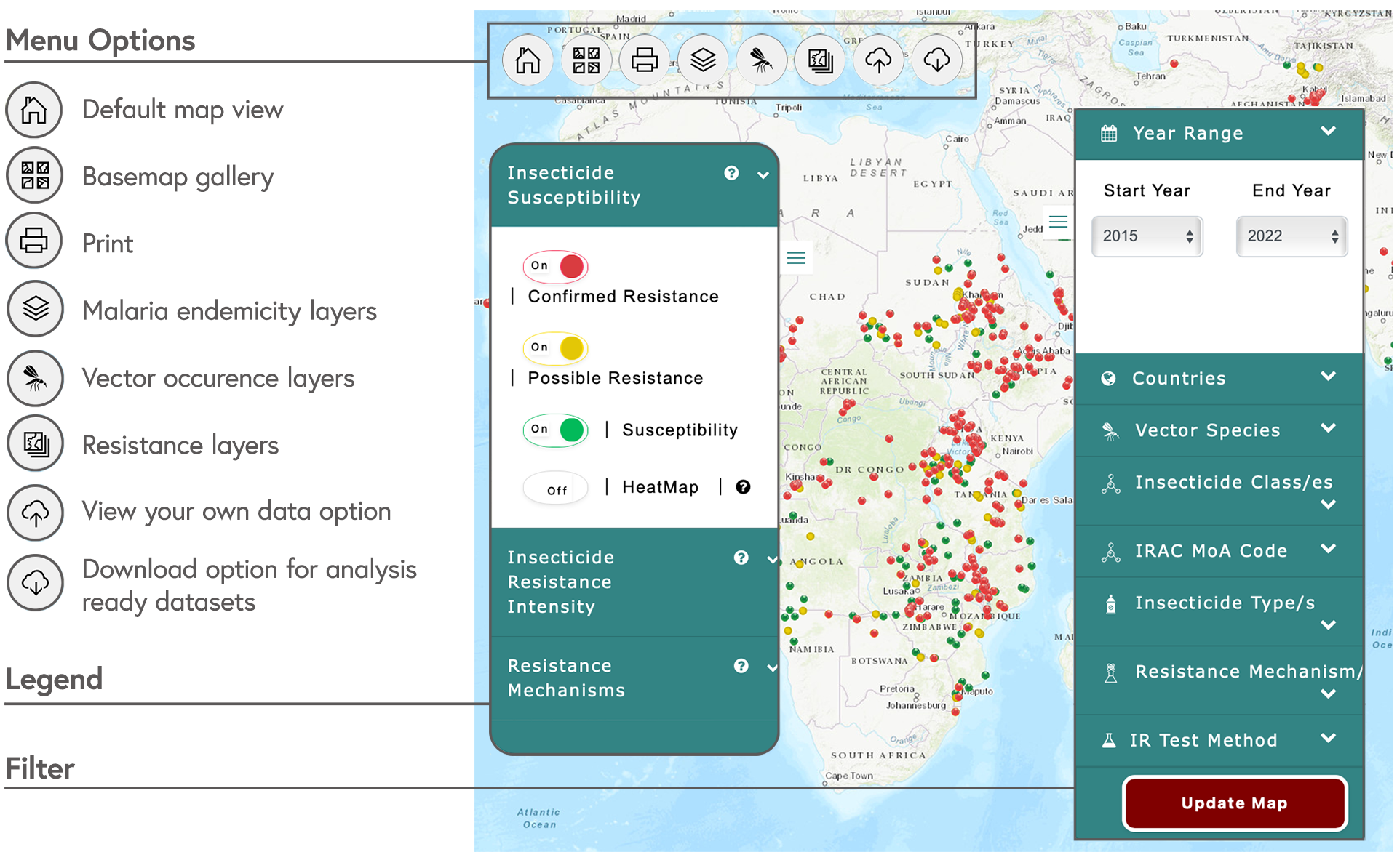
Screenshot of the Anopheles map on IR Mapper labelled to show the menu options, the legend and the filters
[ IR Mapper (Accessed 26 April 2022)